
Introduction
I first learned of the Rinjani races from a blog post on running coach, Andy Dubois’, site. Andy had the good fortune to have been in the area at the time of the running of the penultimate MRU (Mount Rinjani Ultra) 52 in 2014 – then, the flagship race – so he decided to have a crack at it.
His description of the race; the star attraction, Gunung (Mount) Rinjani; the crazy “unrunnable” terrain; all had me mesmerised. I kept a watchful eye on the race, but it was when a new race series was announced for 2016 – including a ridiculously vertiginous 100km flagship race with 9166mD+ of elevation gain – that my interest turned into obsession.

This year – the weekend before last, in fact – I finally got to experience the Rinjani100 for myself.

The Race
Senaru to Senaru Rim (W1)
The 60km and 100km races start together, at 11:30pm on the Friday evening, from Senaru. There are two main access routes for treks up to the volcano crater’s rim – Senaru is the northern entry point. Sembalun – where the race finishes – is the eastern entry point.
With a combined total of 445 registered entrants for the two longer races, the start line was a little bit cramped; but as always, the field thinned out fairly quickly as we made our way up the road towards the entrance of the Gunung Rinjani National Park.
The road from the National Park gate varied in gradient – alternating between flatter sections and “hands on knees” – but it was, on average, a consistently steep climb that had everyone hiking most of the way.
The road gradually became fire trail, which in turn, thinned out into single track. The single track continued to provide plenty of overtaking opportunities, but I picked my targets – overtaking consumes a lot of energy, and with an enormous amount of climbing ahead, I was trying to maintain a balance between “strong climbing” and energy conservation.

The single track wends its way through the jungle; twisting and turning; presenting myriad tree roots to navigate through and around, and dirt ledges to climb. There were very few opportunities to “run”, as for the most part, the terrain and/or gradient dictated.
The terrain eventually began to open up, as we edged closer to the rim. With still quite a long way to go, we could finally see the sky, as the jungle turns into rock and dirt. There was a fair bit more “climbing” in this section, as sections of trail were interspersed with almost vertical slabs of rock.
After the usual spate of false peaks, and about 2000m of elevation gain, we finally reached the Rinjani rim.
W1 to Lake Segara Anak
From the rim, began the descent to the lake in the centre of the crater.
The path contained many sections that required us to “climb down”, mostly with the support of the rocks surrounding the path, and occasionally using steel support rails.
Every now and again, there were passing opportunities, but they are few and far between, and provide a very small window. Wider path sections weree much safer places to do so, than through the narrow rocky climbs.
Lake to Sembalun Rim (W2)
Once down at the lake surface, the path followed the lake around to the climb up to the Sembalun side of the rim.
It was a great shame that we did all of this at night time, as we were unable to see the lake up close, in all its glory. Luckily, there was plenty of time ahead, to see and photograph the lake from far above.
The climb up to the Sembalun rim was relatively unremarkable, but we did start to see our first glimpse of the infamous “scree”.
W2 to Summit (W3)
We passed through checkpoint W2 twice; once on the way up to the summit; and again on the way down to Sembalun.

This was a very well provisioned and popular checkpoint. The night air had become much cooler as we ascended, and many runners appeared to be revelling in the warmth and comfort that provisions and campfires alike, provided.
This is where I donned my thermal top and gloves. Although not particularly cold, we knew that it would become colder towards the summit, as the altitude and wind chill kicked in.
The climb to the summit… was hard. We knew it would be hard. We were told it would be hard. “Two steps forward, one slide back”. Everyone who made it up there is now vividly aware that there is no amount of reading that can prepare you for the doing.
Most people that I observed, ended up adopting the following strategy:
- Take 2-3 steps
- Lean on poles, exhausted
- Slide back 1 step
- Repeat
It really is that difficult. I saw no-one, myself included, who could make relentless forward progress. Periodic breaks were inevitable.
I did, however, find that it was possible to make more consistent progress by forcing the “work interval” to comprise at least 20-30 steps, counting them off in 10s. You can also improve your chances of halting slippage by targeting larger rocks – they are often, but not always, more stable.
In addition to the larger rocks, I was on the lookout for “grassy”, scree-thin, sections. They are often along the edges of the trail and they are much more stable than the deep blanket of scree that covered most of the path before us. Yes, to take advantage of these, you do generally have to stand closer to the abyss
NB: A small point of courtesy. When you are leaning on your poles for a break: PLEASE place your poles straight out in front of you, NOT out at a 60⁰ from your body. The latter means you take up twice as much space, as people behind you attempt to pass.
NB also: Trekking poles are a pushing tool, not a pulling tool. I was astonished to see so many people who had no idea how to use them efficiently. Buy the correct size, and learn how to use them!
Somewhere on the way up, I took off my right glove to take some photos, and dropped it without noticing, until I’d climbed at least another 10-15 mins more. There was no way I was going back for it, so I left it to chance that I might find it on the way back down – alas, I did not.

As we climbed higher and higher, with the tiny “ant people” off in the seemingly unreachable distance, the wind began to build. If the scree wasn’t enough to contend with, a head-wind strong enough to blow you off your feet, was just what we needed to propel us along.
Everyone I have talked to went through periods of believing that we would never reach the top. Extremely slow progress, and the enormity of the peak above us, makes it appear that no matter how many steps you take, you are never drawing any closer. The congo-line of people further up, never appeared any larger.
But, step by step – pause by pause – breath by breath – I eventually made it to the summit. Once there, those of us who persisted were rewarded by an epic 360⁰ view, with stunning views down to the lake surface below.

At this stage, at the 22.5km mark, we’d accumulated over 3,500m of elevation gain.
Time to collect the 1st of three wristbands (we had to collect three throughout the race, to prove that we followed the correct route), and make our way back down.
I was interested to note that I did not appear to be overtly affected by the altitude. This was my first time anywhere near being that high up, but although it was physically very difficult, I experienced no unexpected breathing difficulties. I did, however, have a brief dry and raspy cough at the summit, that went away as I began to descend.
Be warned though, that I did speak with others that experienced some of the usual deleterious effects; including the somnolence, nausea and vomiting.
W3 to W2
Holy fun!!!
This was my favourite section of the race. The ridiculously slippery, impossibly untraversable, loose scree – that consistently confounded our upward progress – became our inner child’s favourite playground on the way down.
The descent from the summit was a golden chance to make up lost time, throw caution to the wind, and enjoy the free speed, skating over the deep rolling scree surface.
Not to everyone’s taste, most people appeared to be content to slowly and carefully make their way back down in at most, a controlled trot.
As on the way up, W2 was a haven for competitors; buzzing with activity, littered with resting bodies, and doing all it could to service people’s needs before they continued down the mountain.
While refilling my water bottles, I came across fellow-Aussie, Damian Smith. He’d had a shocker of a start to the race, and had succumbed to overwhelming somnolence. As he slept at W2, he had slipped back into the mid-30s in the placings.
Not long after making my way out of W2, and down the mountain, Damian passed me as I put my headlamp away (I’d forgotten to take it off), and applied some sunscreen. It was the last I saw of him, until we were all back at race HQ.
W2 to Pos 1 (W4) and Sembalun (W5)
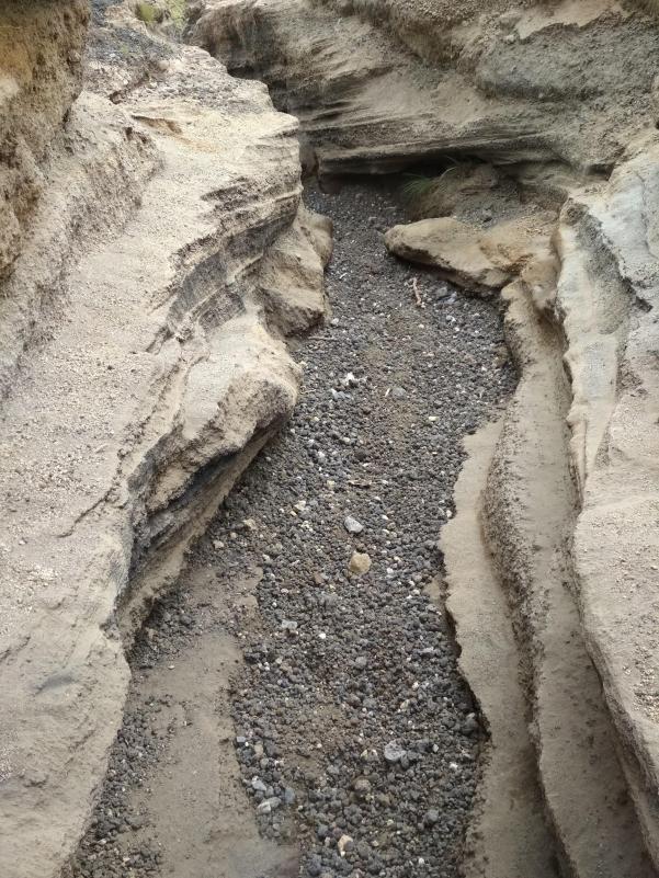
The dusty dirt trail down from W2 was where we learned that the slippery scree is not the only surface poised to put our stability in peril.
I saw far more people hit the ground – again, myself included – in this section, than on the way up to or down from the summit. Take a look at the pictures of this section, and you will find plenty of visual evidence.

Once I’d become a little more accustomed to the (lack of) grip, this section provided numerous paths for passing. Winding its way down the mountainside, the slippery dirt eventually gave way to single and fire trails through the rolling foothills.

A short section of jungle single trail, and a creek crossing or two later, and we found ourselves at the W5 checkpoint in Sembalun. The checkpoint is just around the corner from the Sembalun entrance of the trail up to the Rinjani summit; so we’d essentially completed the equivalent of a standard 3 day 2 night trek.
W5 is the bag drop checkpoint for 60km runners; but the 100km participants had to wait until the W6 checkpoint, another 11km further on, before they could access their stashed provisions.
This checkpoint had by far my favourite “service” – a bucket of iced water, with which competitors had their necks and heads cooled down. It would have been great to have seen this repeated elsewhere along the race route, but such as it was, it was very much appreciated.
W5 to Likun (W6) – Over Bukit Pergasingan
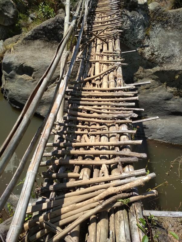
The route from W5, traces its way through some rice paddies, before crossing a river via a rickety old bamboo bridge. Not long after, the next ascent begins.
The first of the “hills”. The climb up Pergasingan brought Lombok’s heat and humidity, in all its fury. Although “only” hovering between 32 and 33⁰C, the gradient and climatic conditions, had everyone pausing for respite in the all too brief sections of tree canopy cover.
This, and the subsequent “hills” slowed my progress significantly. It was where I began to lose most of the time that I would sorely require, later in the race.
Once at the top, we secured our 2nd wristband and started to make our way down.

Once again, the path down quickly degraded into a steep and slippery, dust bowl of a trail. At the bottom, we traversed a set of concrete stairs, turned left, and followed a series of rolling dirt road hills leading to W6; the 100km runners’ drop bag checkpoint.
W6 to Sembalun Bumbung (W7) – Over Bukit Anak Dara
At W6, I fell prey to my biggest single time-sink. What time I hadn’t wasted in the heat, I left behind in a chair at W6.
Some of the lingering was strategic – I restocked my pack with water, and nutrition; washed my feet and put on new socks – but I was there for well over 30 minutes, which was far more than required.
At least for this next climb, the sun had had the sting taken out of it, and much more of it was under the cover of the tree canopy. Far easier going, but still relentlessly steep, this again had some short sections of “hands-on” climbing to navigate.
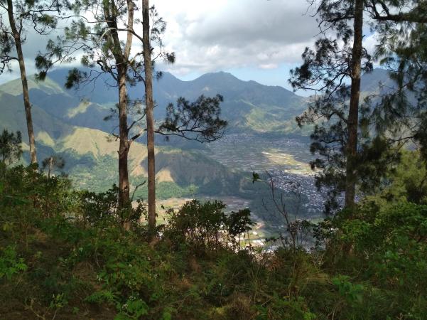
The reward at the top, was very special – an open green grassy ridge line, with an easily visible, and rather pretty trail winding through it.

The other side, however, presented the weary traveller with yet another of Rinjani100’s infamous descents. So steep, so loose, so slippery, with a trail so occasionally narrow, that it is sometimes more akin to a (sheer drop of a) wall than a trail.
A couple of short sections had an almost comical piece of “rope” to assist the descent – the thin blue synthetic string that people use to hang their clothes rather than a real rope – but this sought to mock us more than offer any real cause for comfort.
So very slow going, it became abundantly clear that much of this race is as difficult and measured on the descents, as the ascents.
The bottom of this descent took us through the streets of Sembalun Bumbung, then back out to wind our way through and around some more rice paddies, then finally onto some dirt road to the W7 checkpoint.
60km in, and with night having now fully closed back in, this was a checkpoint popular for its hot food and drink. Many people lingered here, and some even slept, but I figured I’d had enough of that at W6 and left after quickly replenishing my water supply.
W7 to Pusuk (W8) – Over Bukit Montong Karang, Batekan, Nanggi, Solong and Tanah Abang
Land of a thousand hills.
The initial climb here was long – very long – steep, and dusty. It was preceded with a gradually increasing incline, after wending our way along a dirt road and up a dry creek bed. But as soon as it started climbing, it really never did relent, for what felt like hours (it probably was, in my case) all the way to the “top”.
What followed reaching the “top”, however, was an interminable series of additional “hills” on top of that first peak – one after the other, each of which mocked the one before it; the crest of each peak revealed yet another, and another.
At Nanggi, ostensibly the 3rd of these meta-“hills”, we collected the 3rd and last of our wristbands. A wristband is unnecessary along the following (and final) set of hills, as there is no way off the mountain, other than the intended route.
As this section was navigated in the dark, it was not possible to see much of what lay before us. A great shame, as the pictures I have seen of some of the ridgelines there, are spectacular. Sharp drop-offs on either side. Beautiful lush green grassy slopes. Rugged rocky outcrops. Mostly, all I saw was the flash of the flagging tape in the shadows.
The hills and trails progressed through quite a number of “tent cities”; a popular destination it seems, as are all of the area’s hills, for weekend excursions into the great outdoors for the locals.
One of the more deserted meta-hills is where I experienced my only period of truly uncomfortable cold. Cresting the top of this particular hill, the cloud cover had descended onto the mountain top, causing pea-soup thick fog and bringing a howling wind. Wind and rain combined to cut straight through me; and from what I later gathered, anyone else up there at the time. I hadn’t packed a spray jacket, but my single glove and fleece were enough to keep me relatively warm and dry.
Not far from there is where I encountered two pieces of equipment failure:
- My headlamp began to fail. So I had to change the batteries with cold-numbed fingers (still missing my right glove). This is really difficult to do in the dark. I had my spare torch, but using it to direct enough light onto the headlamp, and fiddling with the batteries – all while increasingly fatigued – took many times longer than it would have in ideal conditions. All for nought, the new batteries threw no more more light than the old ones.
- The top of one of my water bottles came off. Each bottle has a “bite” valve. Somehow, it came off and dropped onto the trail somewhere and I didn’t notice until much later. I heard it sloshing, but didn’t connect the dots.
Hill after hill after hill; sheer drop, after almost vertical wall, after steep slippery dust trail; I finally found my way to the W8 checkpoint in Pusuk, having completed 73km.
This, was unfortunately where my journey ended.
When I got to the checkpoint, I was asked if I wished to continue; or pull out, as had a number of the people ahead of me. But not long afterwards, the decision was taken away from me; as I was advised by the checkpoint doctor that due to safety concerns, I would be unable to continue as I did not have at least 8hrs up my sleeve before the finish line cutoff.
It is not an official cutoff point, but a decision imposed to ensure the safety of participants, officials and volunteers. The remainder of the race is all conducted on a single mountain range, from which participants cannot be evacuated if anything goes wrong. The race officials have been bitten by this in years past, and I certainly didn’t want to be stuck up on a mountain, while my plane home went without me.
While disappointed, I completely understand and fully support the decision.
In retrospect, having had only 7 ¼ hrs until the finish line cutoff, I was not likely to be able to cover the 26km remaining, given the elevation change and terrain.
W8 to Propok Valley (W9) – Over Bukit Propok and Kondo
I’ll let you know after my comeback, after which I will have completed the race; and hence, this section.
W9 to Dandaun Valley (W10) – Over Bukit Turunan, Bawan Duri and Lincak
I’ll let you know after my comeback, after which I will have completed the race; and hence, this section.
W10 to Sembalun (Finish) – Over Bukit Telaga
I’ll let you know after my comeback, after which I will have completed the race; and hence, this section.
While I didn’t get to finish the race, I can tell you that the race finishes back in Sembalun, at the Hotel Nusantara. The hotel was also race headquarters; home of registration, gear check, bag drop, race briefing, and all other pre-race administrative functions.
After being delivered back to race HQ, I was also able to watch Damian Smith – fellow Aussie, our only finisher, and now good friend – cross the finish line, having clawed his way from his earlier slip into the mid-30s, back up to 8th place. A gritty and truly stellar performance.
Lessons Learned
Terrain
It is ridiculous. I was saying that to all and sundry prior to the race, but it is impossible to convey just how insanely hard this race is, without showing it to someone in person.
There are no words.
Everything is slippery – the scree, the dusty dirt, the grass – everything. Most of it is steep. Going down is just as hard as going up – sometimes harder.
Most of the race is “unrunnable”. That sounds like hyperbole, but it is simply the truth.
Climate/Weather
From oppressive heat and humidity to single-digit cold with wind chill. You need to prepare for, and endure a wide range of climatic conditions.
Equipment
Don’t just pass gear check. That is always a fool’s errand, but for this race, it will almost certainly be at your peril.
Get a good quality headlamp. Plenty of light, and longevity.
Use poles, but put them away and use your hands when descending. I didn’t do that nearly enough, having become frustrated with the difficulty of securing them over and over again.
Make sure your water capacity is sufficient and secure.
Nutrition
Nail nutrition; make a solid plan, and stick to it without fail.
I am no longer sure where it all began, but at some point the wheels began to fall off my nutrition plan. I had trialled VFuel gels in a couple of long training runs with much success, but this was my first time using them in a race. I had never used any kind of gel, previously.
To their credit, they worked perfectly when I was actually consuming them. Went down really easily, never got sick of them, and felt good each time I had one. But sometime between 50-60km I had slowed consumption, and by 60-73km I was barely eating at all.
This helped to feed a bit of a cycle of being “resigned to fate”. While committed to continuing no matter what, I no longer felt in complete control and was merely putting one foot in front of the other.
Was it the lack of nutrition causing brain fog? Or brain fog causing the lack of eating? Or both? Not sure, but in future, I’ll be doing something more concrete to make sure that I stick to the plan.
Checkpoints
Same as usual. Get in and get out. Don’t muck around, but do ensure that I don’t leave without everything I need.
Again; make a solid plan, and stick to it. But with this, be adaptable when required.
Energy Conservation and Strategic Rest
Many people, myself included, were regularly “resting” on our poles as the fatigue and heat set in, without any obvious rhyme or reason.
Far better, as I observed in some other competitors, would have been to “strategically rest” – lie down in a shady spot to more efficiently regain some energy – then push on with purpose.
Epilogue
So, how was it?
The most beautiful, brutal, exciting, heartbreaking, soul restoring adventure that I have ever experienced.
Will I do it again?
In a heartbeat. I started missing Lombok as soon as I hopped on the plane to leave. I am now counting the days until my return; to finish the race, see the rest of the course, and bathe in the solace of the place that very quickly felt like a second home.
Is next year too soon?

Thanks for sharing, mate! And congratulations again, all of your hard works paid off. Good luck with your next-next race.
PS. I am still working on the #RINJANI100 – 36 K experience. 🙂
LikeLiked by 1 person
(To add up my previous reply) — I didn’t really read the whole article so I thought you d made it all the way. But you did a great great job…since you have come so far.. I dont think I could do that 73 KM…
LikeLiked by 1 person
Thanks Bee.
While I wish I’d made it to the finish, I’m pleased that I have a great excuse to go back. Hopefully very soon.
LikeLiked by 1 person
Terima kasih atas ceritanya. Banyak pelajaran dari pengalaman Anda. Sekali lagi terima kasih.
LikeLiked by 1 person
You are very welcome.
I’m pleased that you found it useful.
LikeLike
nice review 😊 very enlightening .
thanks for sharing n’ good luck for the next race 🏃
LikeLiked by 1 person
Thank you. I’m pleased that you liked it and found it useful.
Rinjani has had a huge impact on me, but I do have to try to put it behind me for now, and focus on the next adventure.
LikeLike
thanks for sharing. It’s very useful & informative, for everyone who want to try 100k category next year 🙂
LikeLike
Pingback: Rinjani 100 - Explore Unbound
Thanks for sharing mate! It is very comprehensive review of Rinjani100. I will run it next year. Wish to meet you there for comeback!
LikeLike
You are very welcome!
Rinjani 100 is one of the few races that bring get me back to trail racing. But I stopped trail running back in 2019. Finally made a minor comeback last year and went on a total of 9 runs (once a week for a couple of months). But I don’t think I will ever devote the time and effort required to complete something like that again.
Mountain biking has taken over my life, so if I ever did something like that again it will most likely be on a mountain bike!
Still very much looking forward to going back to Lombok, though. It was a wonderful experience.
LikeLike